3F PID2023-149573OB-I00 ← Mihai Tanase
Ministerio de Ciencia, Innovación y Universidades; Cofinanciado por la Unión Europea; Agencia Estatal de Investigación
Proyecto PID2023-149573OB-I00 financiado por MICIU/AEI/10.13039/501100011033 y por FEDER, UE.
Ongoing project · principal investigator

Fuels, Fire, Flourish: remote sensing synergies to unravel fuel dynamics, fire impact and forest recovery

3F builds an integrated system that follows live fuels through every phase of a fire — from pre-fire fuel status, through combustion and fire impact, to post-fire recovery — using terrestrial, airborne and spaceborne sensors. It takes advantage of the first dual-frequency (S- and L-band) SAR mission, NISAR, and of near-simultaneous C-band (Sentinel-1) and L-band dense time series, and it applies artificial intelligence to integrate data streams from national, European and international Earth Observation programmes.

Objectives

O1

Characterise and monitor fuel structural properties

Canopy fuels — fuel load, canopy height, canopy base height, canopy cover, canopy bulk density — and understory fuels — density and height. Reference information comes from high-density airborne lidar, propagated through time and space with satellite time series, pixel-level disturbance history (1985–2024) and ancillary climate and terrain variables. Terrestrial laser scanning provides the bottom-up view needed to separate understory from canopy.

O2

Fire impact assessment and emission estimates

Redevelop the Radar Burn Ratio within a multi-sensor, multi-wavelength framework so that it carries information from both the top of the canopy (C-band) and below it (L-band), adding interferometric coherence and L-band scattering-centre height. Biome-specific indices are pre-calibrated against in-situ observations, then combined with fuel load to estimate greenhouse gas emissions through a book-keeping approach.

O3

Post-fire recovery from active-passive sensor synergies

Track recovery in all major fire disturbance events in the Spanish Atlas of Forest Disturbances. A repurposed CCDC-SMA analysis detects positive change in the optical signal, then lidar and L-band radar take over where optical reflectance saturates, giving structural recovery rather than cover recovery alone.

Approach

Demonstrator areasGalicia, Basque Country, Madrid, Andalucia

Large (2–3 M ha) areas forming a north–south transect across the Atlantic and Mediterranean biomes, with contrasting vegetation types and fire regimes.

FuelsPNOA lidar 3rd campaign, TLS, NFI

The third national PNOA lidar campaign at 5 points m⁻² provides the reference canopy fuels; SLAM terrestrial scanning adds the understory; National Forest Inventory plots calibrate the biomass fractions.

Fire impactSentinel-1 C-band, NISAR L-band, FLEX

Multi-wavelength backscatter, coherence and scattering-centre height for a pre-calibrated Radar Burn Ratio; in-situ fire impact data collected in large (>500 ha) fires.

RecoveryHarmonized Landsat Sentinel + lidar + L-band

A 35+ year optical trajectory for regeneration, extended with structural recovery from lidar and radar once the optical signal saturates.

Results
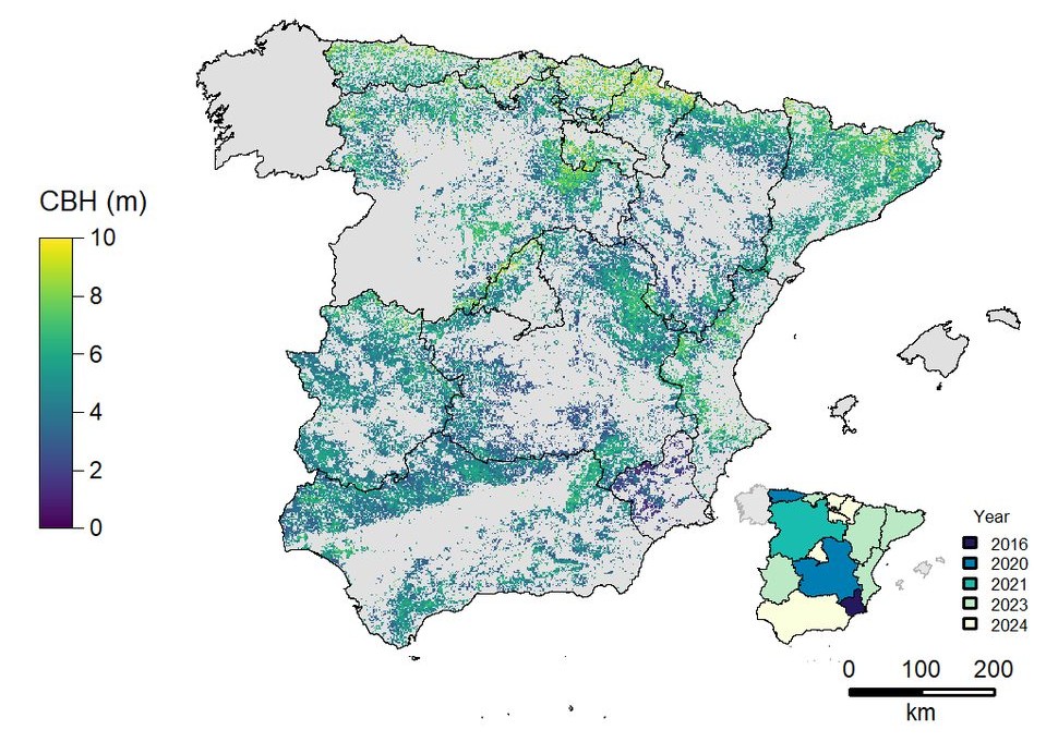
Canopy base height
Canopy base height Canopy base height across peninsular Spain at 40 m, predicted by the patch-CNN from national airborne lidar. Inset shows the lidar flight year by region. Tanase, Garcia-Martin & Lamelas, under review
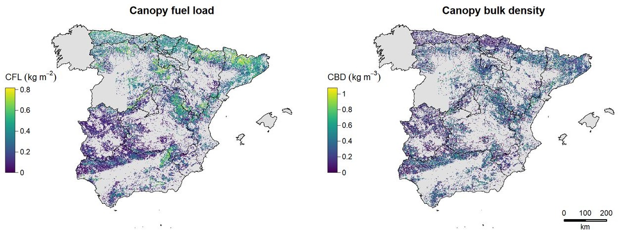
Canopy fuel load and bulk density
Canopy fuel load and bulk density The two canopy variables that determine whether an active crown fire can be sustained, mapped over the same area. Tanase, Garcia-Martin & Lamelas, under review
Deep learning against machine learning
Deep learning against machine learning RMSE by region for the tree-stratum variables, comparing the patch-CNN with random forests and gradient boosting. Tanase, Garcia-Martin & Lamelas, under review

Publications

Mapping multi-strata forest fuel attributes across peninsular Spain using airborne lidar data
M.A. Tanase, A. Garcia-Martin, M.T. Lamelas Gracia
Remote Sensing of Environment
under review
Mapping fungal disturbances and logged areas in Pinus radiata forests: a multi-method comparison of Harmonized Landsat and Sentinel-2, Sentinel-1 and AlphaEarth embeddings
V. Wilke Mateos, A. Cantero, M. Tanase
Manuscript in preparation
draft
Mono-temporal mobile laser scanning reveals species-specific vertical structural signatures of fire severity in Iberian pine stands
M.A. Tanase
Manuscript in preparation
draft

Team

Mihai TanasePrincipal investigator · ICIFOR INIA-CSIC
Alberto García MartínResearch team · Centro Universitario de la Defensa, Zaragoza
María Teresa Lamelas GraciaResearch team · Centro Universitario de la Defensa, Zaragoza
Diego Laino RebollidoWork team · University of Alcalá
Victoria Wilke MateosDoctoral student, joined after the application
Guillermo Goday AramburoDoctoral student, joined after the application